About a year and a half ago, Ron an I were sitting in our kitchen in Ann Arbor, Michigan, on a cold and windy day, reading the Sunday New York Times. Looking thru the travel section (one of my favorite sections), we read about different cruise experiences on small ships.
Inner Seas Discoveries (www.innerseadisoveries.com) caught our attention. A small ship, less than 30 cabins, presenting a different un-cruise experience thru Alaska's inner passage. Up close experiences, with hiking and kayaking daily ....
The boats were booked for the trip we wanted that year, but we booked for the following year, May 2012. We had no idea where we would be, it was months before we put our house up for sale. Six months later, we sold our house, moved to Florida.
Ron had one of his briliant ideas - let's drive to Alaska, and our six month road trip was created.
It is now time for us to take our cruise ....a year and a half latter.
During our 15 day cruise we will be taking many pictures, but we won't have internet connection, so pictures and details wil come later. When we get off the cruise the first week of June.
We'll be back with more.
Friday, May 18, 2012
And onward to the last American frontier - Alaska
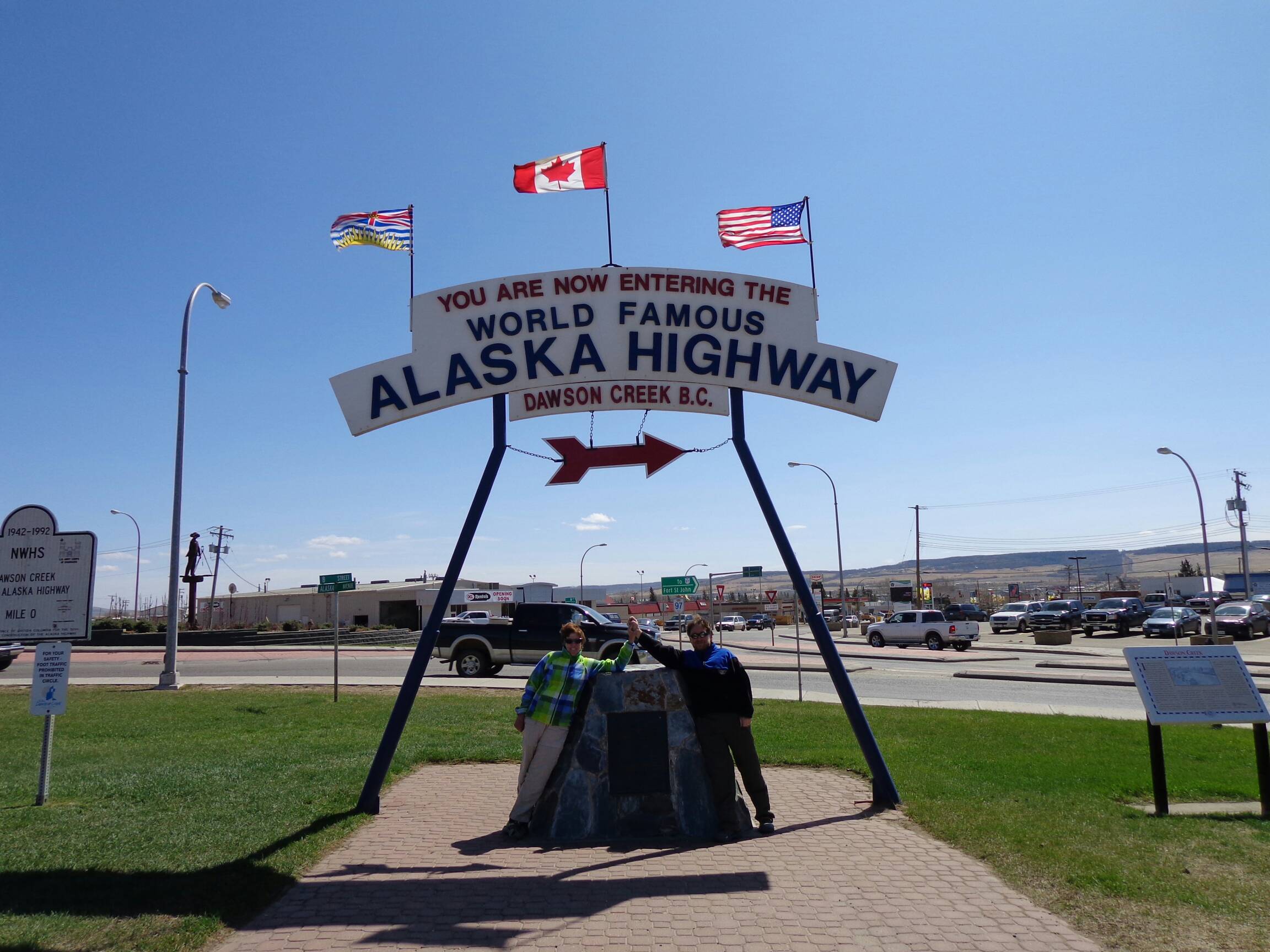


After our stay in Banff and Jasper, we began our final push to Alaska. In approximately 300 miles, traveling along the northern end of the Canadian Rock is, we reach mile 0 of the Alaskan Highway - Dawson Creek. The Alaskan Highway, aka Alaskan-Canadian Highway, aka The Alcan, is a two lane 1387 miles from Dawson Creek, British Columbia to Delta Junction, Alaska. It was built in 1942 by the US army, with Canada, to connect Alaska with the US mainland to serve as a supply route, and a way to protect the US. The majority of the road is in Canada.
It travels through the Yukon and gave a different view of Canada than a stay in Banff. Much of the road is empty of people and buildings .... and drivers.We saw our first bears right on the side of the road. Our first overnight was in what seemed to be a brothel - from our check in process -'what would you like?' to the paint on the walls - purple with black velvet pictures, the late night check ins, and the lack of evidence of those check ins still there in the morning.
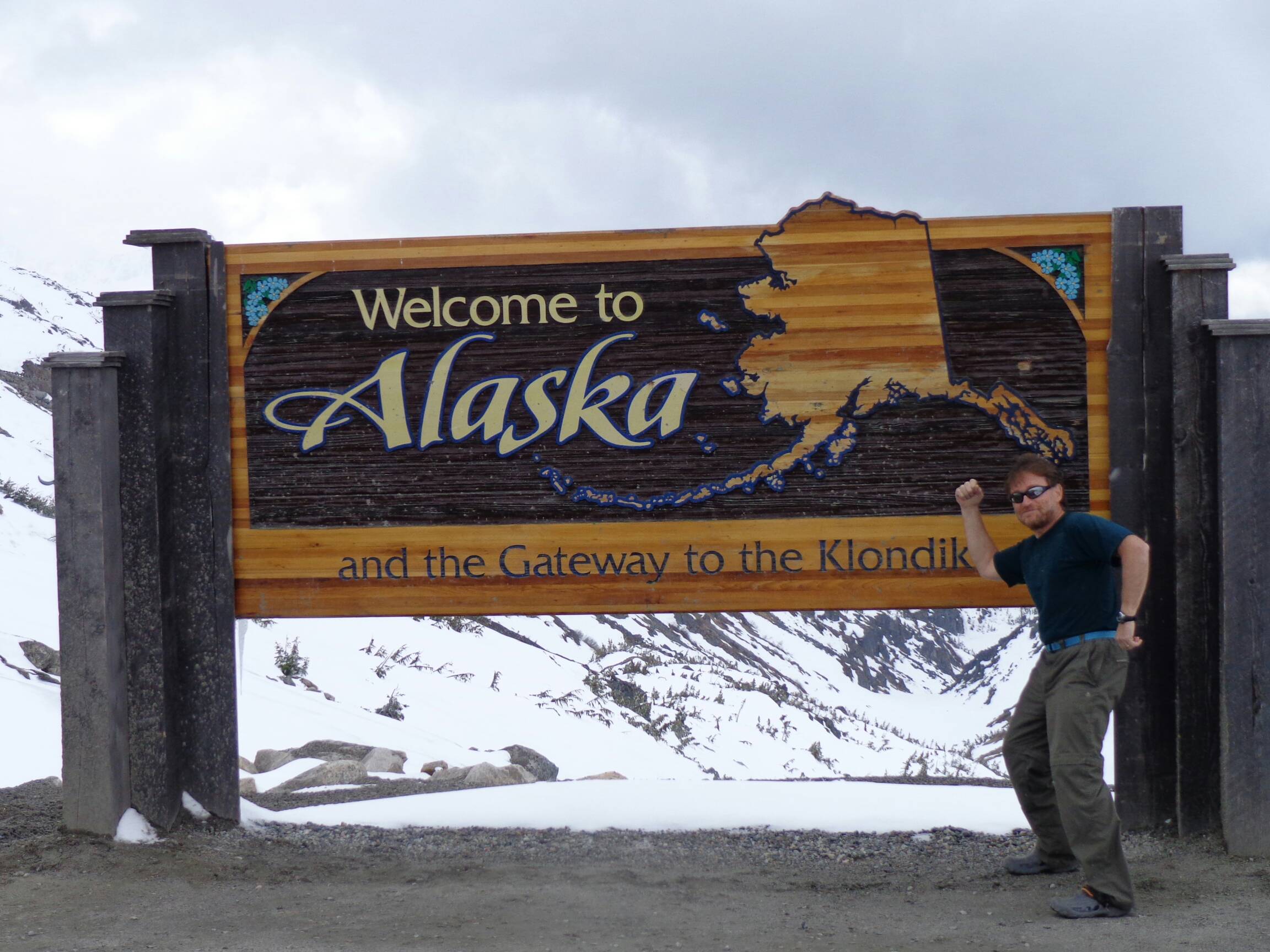
Our second night we stayed in a historic US Air Forece barracks in Watson Lake in the Yukon, most famous for its signpost forest, here signs from all over have been posted. On our third and final day on the highway - we hardly saw another driver as we drove our way across the border into Skagway, Alaska. Before getting to US customs we saw a frozen, snow covered no man's land stretching for 10s of miles; just a foreshadow to the tails of earlier stampeders who arrved in Skagway and Dyea each to start a treachorous climb up the Chilikoot Trail or up White's Pass at the start of their journey to Dawson City during the Klondike era of 1897-98.
Next stop - Skagway - home to 900 residents and 850,000 cruise visitors in the summer month. Today's gold rush being sort by the diamond, tanzanite, T-shirt and saltwater taffy vendors lining Broadway, downtown Skagway. between night and day this small town turns from barren Hollywood set to Main Street, Disney.
Published with Blogger-droid v2.0.4
Thursday, May 17, 2012
Gold Mining, Then And Now


Skagway, and its sister Klondike seaport entry, Dyea, is no less a scavenger hunt today than it was 115 years ago. Tour guides, tour buses, walking tours, NPS guided tours, helicopter and airplane flights leaving every fifteen minutes, railroad tours to White's Pass on the half-hour. Get your activities scheduled, slots filling quickly. Activities to meet any and very interest close at hand. By late afternoon only the hardy are still walking Skagway's B'way, a la 'Dawn of the Dead' , with a final thirst quencher still available up at 7th Street at the Skagway Brewing Company where the Chilicoot IPA takes honors over a host of other local brews.
photos:
Karen stands behind the restored tombstone of 'Soapy', Skagway's original kingpin, intent on mastering every local racket designed to offload any successful gold miners of their discoveries, as well as prey over every down-on-his-luck seeker. Skagway 'Goldminers Cemetery';
Scene at the Dyea Slide Cemetery, where the 70 of so misfortunates of the Chilikoot avalanche of 1898 were brought to rest;
Skagway harbor occupied on cruise ship invasion by daylight;
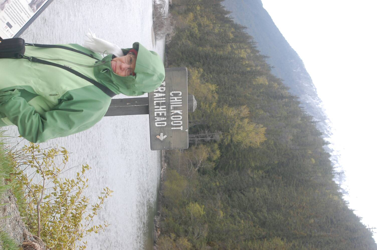
Along the Chilkoot trail, or any canyon or forested coastal trail we've walked so far, mosses, ferns, and lichens grow thick and lush on forest floors, rock walls, and lining trees in these dense forests;
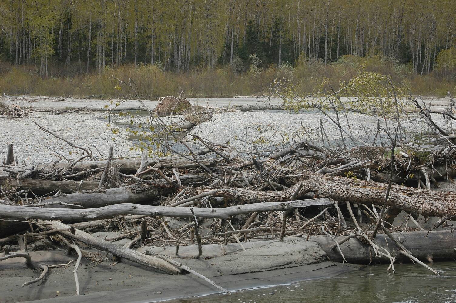
The Chilkoot river runs wild in season, trees, brush and sand swept down the valley floor;
33 Miles to the top? Where are the dog sleds? Where's the tramway?;
Above Skagway, along the shores of Lower Dewey Lake across dense forest trails;
Published with Blogger-droid v2.0.4
Saturday, May 12, 2012
Animals On The Road and other places


Since departing Hollywood five weeks ago we've encountered the wild, the domesticated, the caged, and the carion as well. Roadside, and seaside, the highlights now include:
Dolphins - near offshore in the Florida panhandle
Marmots in the Tetons and Yellowstone
Grey Wolf in Yellowstone
Bison - Yellowstone and points north
Elk - Yellowstone
Caribou - Canadian Rockies
Big Horn Sheep - Canadian Rockies
Stone Sheep - near Stone Mt, North Canadian Rockies
Bats - Moab, Utah
Grizzly Bear - North Canadian Rockies
Lots and lots of Raven feasting on hot road meals
Published with Blogger-droid v2.0.4
Friday, May 11, 2012

Thursday, May 10, 2012
I Said Glace' not Glacier
Leaving Banff behind we head down Canada 1 Highway to Lake Louise - a definite stop on the tour for all including multiple tour busses. It was a feast of views in all directions. We saw snow covered mountain tops surrounding us as we drove to Lake Louise, and herds of big horn sheep.
It was hard to believe it was a lake. Frozen solid in May, covered with ice. Even cross country skiers were still comfortable skiing the lake -
We have pictures to post from Lake Louise and updates from our stop in Jasper, the northern part of the Canadian Rockies. Unfortunately, we are suffering from limited bandwith.
Daily hikes outbound from our lodge on Pocohantus. A river canyon, swirling and carving softer rocks have left behind a steep yet narrow canyon gorge; a walk along a dirt road midst pine trees in search of the river bottom; and finally a walk along a trail overhanging a wide valley river basin. Returning on this last walk, surprise, a small group of six mountain sheep lined the trail ahead. Patiently they stood and posed for today's photos in the wild.
Tomorrow we start our drive to mile zero of the Alaskan Highway - and will have plenty to add to our blog. Anticipation builds waiting to discover how many others will join us on our trek along the AlCan.
Excitment grows as well as we're now one week and two days from cruise departure on Juneau. Over a year in planning our date is approaching.
Stay tuned. Photo catchups coming.
Sunday, May 6, 2012
Banff - Mountains to the Left, Mountains all Around

The town is much busier than West Yellowstone .... but it is still quiet - the time between the winter and summer seasons. Lots of restaurants in town - we ate at a gourmet burger bar, an Indian restaurant, and a pub with elk steak and bison burgers.

We're enjoying our new panaromic camera. We took great pictures on our many walks. We started out from our lodge on Tunnel Mountain and walked into town, and over to the Bow River trail - and the Spray River trail. After our 6 hour walk - everything in and on my body hurt but we got wonderful pictires.


On our second day, finally, the clouds and rain had disappeared and a clear blue sky was shining from early AM, from snow covered peak to snow covered peak in every compass direction.
Having reached near exhaustion over the course of yesterday's hike we chose a more modest endeavor for today. A lake-side walk and canyon trail just north of town would be our warm-up, perhaps a shorter meadow walk to follow.


What a difference a day makes. Yesterday's hillside mud streams has given way to today's soft pine needle ladden trail. Of course not forgetting cautions to hikers to proceed only in close groups of 4+ so as to increase ones chances of surviving a bear encounter!


Friday, May 4, 2012
Oh Canada! Oh Canada!

More tourists strolling downtown Banff than we've seen in the past four weeks. Not to menton how scarey it was driving through traffic in Calgary. Now that's a big city!
A well deserved lunch break and off we went strolling fields and marshes just across the town bridge. More noisey tourists. But great vistas of snow covered peaks surrounding Banff. Like the panorama shot above taken with Karen's new Sony Cybershot?
A short touring day so following are some of the magnificent views about town.......


A Short Over The Pass...A Day Enroute
Thursday, May 3rd. Early start today as we begin our first of a two day drive from West Yellowstone to Banff. With weather being more late winter than spring we were none too sad to be leaving this ghost town, albeit Yellowstone is a continually unfolding fantasy land.
Mabel, our gps guide, had us set for an11.5 hour drive over the next two days. Setting out the roads north of West Yellowstone remained as empty as town, yet now with expansive views across valleys,ranch lands, and surrounding mountain ranges. Until.....police car lights flashing ahead, the road clearly closed. Multiple car flashing lights, cowboys on horses across the road? Cattle crossing? Not quite.....
 Oh, its a cattle drive alright. Only this one is not going to market. These National Park Ranger cowboys are leading their herd back to summer grazing pastures in Yellowstone.
I guess we'll just pull over and enjoy the show for awhile.
No stopping this march, nor getting out of one's car!

 Surprise. Nestled in with the herd were several calves of the bison variety. Cute aye!
And of course, no outing is complete without
treats for the littles.
Once the herd passed we resumed our trip. Next up, Earth Quake Lake, created in 1959, following a massive earthquake which shifted, stopped and created many new geysers within Yellowstone 50+ miles away. The lake was created as a mountain toppled and a river's course altered.
The next several hours took us through several high meadows, passes and across
rolling farm plains which stretched to the earth's curvature. Spellbinding vistas in all directions, anew over each mountain pass and through each canyon road.
And on we drove, marvelling at the vistas, not a town worth stopping for insight over the next eight hours. Passing access roads to Glacier National Park, while driving through Blackfeet Nation reservation lands, still no signs of life worth slowing down for.
Finally, across the border and into Canada, two towns north and we drove into Fort MacLeod Alberta, a town with no less than ten motels, and pizza/steal parlor and two liquor stores.
Okay, okay,enough driving for one day. We checked in to motel number two, walked across the street for brews and a loaded pie.
Nite, nite.

I guess we'll just pull over and enjoy the show for awhile.
No stopping this march, nor getting out of one's car!


And of course, no outing is complete without
treats for the littles.
Once the herd passed we resumed our trip. Next up, Earth Quake Lake, created in 1959, following a massive earthquake which shifted, stopped and created many new geysers within Yellowstone 50+ miles away. The lake was created as a mountain toppled and a river's course altered.
The next several hours took us through several high meadows, passes and across
rolling farm plains which stretched to the earth's curvature. Spellbinding vistas in all directions, anew over each mountain pass and through each canyon road.
And on we drove, marvelling at the vistas, not a town worth stopping for insight over the next eight hours. Passing access roads to Glacier National Park, while driving through Blackfeet Nation reservation lands, still no signs of life worth slowing down for.
Finally, across the border and into Canada, two towns north and we drove into Fort MacLeod Alberta, a town with no less than ten motels, and pizza/steal parlor and two liquor stores.
Okay, okay,enough driving for one day. We checked in to motel number two, walked across the street for brews and a loaded pie.
Nite, nite.
Last day in Yellowstone
Our last day to enjoy Yellowstone National Park, and we have sun! It's still cold, windy - but we can see blue sky. So we dress warmly (for me that includes long underwear) and we head out to the Grand Canyon of Yellowstone.
 The walks were steep and a bit icy.

But the views were spectacular.
And we braved it for the views.


Then it was timge to return to our lodge, and begin to pack up. We'd seen pretty much what we could - so many areas still closed up. It was magical. We will return.
Just a reminder of the glorious experience - the bison showed up again in the field and on the road.
And the elk.


But the views were spectacular.
And we braved it for the views.


Then it was timge to return to our lodge, and begin to pack up. We'd seen pretty much what we could - so many areas still closed up. It was magical. We will return.
Just a reminder of the glorious experience - the bison showed up again in the field and on the road.

And the elk.


Subscribe to:
Posts (Atom)